Overview
Chelan Butte is a world-renowned freeflight site and has a long history of hosting national competitions. Experienced cross-country pilots enjoy the varied terrain: flatlands to the south and east, mountains to the north and west. Chelan can offer a quick winter sled ride, a short XC flight up the lake to Manson, an epic flight to Idaho, and everything in between.
Access to Chelan Butte by pilots is by agreement with WA DNR, and access to our main landing fields is by agreement with Chelan PUD. Please help us maintain good relationships with these entities by reading and following the rules and guidelines here, and by getting an in-person site intro from someone familiar with the site. You can connect with local pilots on Telegram or Facebook, or by contacting the club.
Requirements
- All pilots must be current members of USHPA. Temporary memberships are available for visiting international pilots. Our landowners require this, as it is a condition for insurance coverage.
- All pilots must hold a P3/H3 rating (or international equivalent), or a P2/H2 with instructor supervision. Flat Slope Launch and Turbulence special skills are strongly recommended.
- All pilots must join Lake Chelan Flyers.
- Due to extreme fire danger that is common during flying season:
- All vehicles driving up the Butte must carry a shovel and a minimum 10/BC fire extinguisher.
- Drivers must not drive off the road or park over vegetation.
- Fires and smoking are strictly prohibited on launch.
- Parked vehicles must display a Washington State Discover Pass (available online and at several local stores including Safeway).
- Parked vehicles should not obstruct the upper loop road. Park on the gravel or mowed areas behind the launch area.
- No motors. Our land use agreements are for unpowered flight. Please do not attempt to launch or land any powered ultralight vehicles at our LZs or launch sites.
Site Description
Location: South of the city of Chelan, WA. Launches: 47.8044, -120.0387. Junkyard LZ: 47.8300, -120.0095. Chelan Falls LZ: 47.7989, -119.9849.
Usage: Hang Gliding and Paragliding. None of the Chelan Butte launch sites are suitable for mini/speed wings or other low-performance gliders due to the glide required to reach designated LZs.
Season: Allowed year-round, but the road is often impassable in the winter/spring and hiking/snowshoeing may be necessary for access.
Affiliation: Lake Chelan Flyers. USHPA RRRG insured site.
Land Ownership: Washington State Department of Natural Resources (launch). Chelan PUD (landings).
Other use: Open to the public for sightseeing, hiking, bicycling, and more. Chelan Butte is a fantastic viewpoint so it attracts some activity.
Access:
- Access to launch by vehicle is from US97A in the Lakeside are of Chelan. Turn uphill at Chelan Butte Road. Continue straight until nearly the top, where you will make a right turn to get to the launch area. The lower portion is paved, the upper portion is unimproved dirt/gravel. High clearance and 4WD is recommended. Please drive slowly, especially around the blind turns. Please carpool to keep traffic on the road to a minimum, and to avoid filling up the parking area on busy days. Road is typically accessible mid-April through the first snow of winter. Avoid the road when wet.
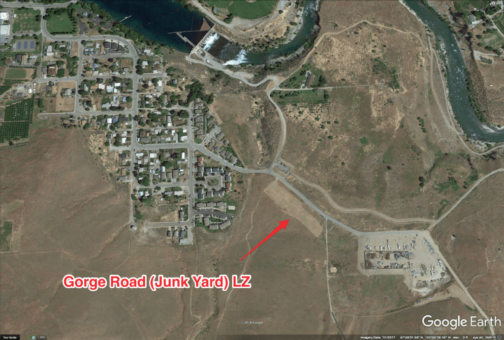
- Launch can also be accessed by a hike, but it’s grueling in the heat of summer. The trailhead is conveniently located across the street from the Junkyard LZ, so if conditions allow, you can land at your vehicle.
Hazards
Pilots are expected to assess hazards for themselves. The following is a summary of some of the hazards that pilots may experience at Chelan Butte, but it is not an exhaustive list.
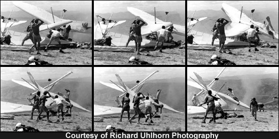
- Dust devils in the launch and setup area can be violent. Hang glider pilots are REQUIRED to use tie-downs for pilot and spectator safety. Never leave equipment unattended when unpacked. Limit your exposure to dust devils by laying out your wing only when you are ready to launch. Use extreme caution when launching in thermic conditions. Carefully evaluate the conditions and determine whether they are appropriate for your skills and risk tolerance. Consider launching earlier in the day to reduce the risk of encountering dust devils on launch.
- The primary risk at Chelan Butte involves evaluating flying conditions at or near launch. There have been two known fatality accidents at launch and numerous injuries to pilots from failed or aborted launches. Thermal activity often results in severe turbulence at or near launch. This is particularly pronounced on light wind days, and during mid-day heat. Carefully evaluate launch conditions before flight. Use a different launch or wait for milder conditions when thermal conditions produce excessive gust speeds. Chelan Butte, at some times, can be a benign site that is suitable for low-time pilots with limited experience. At other times, it can be extremely challenging, even for master-rated pilots.
- Conditions can be extremely turbulent. Pilots flying midday must be ready for turbulence immediately upon exposing the wing to the airflow, and are encouraged to maintain terrain clearance after launching. It is not appropriate to scratch for lift on Chelan Butte. The safest course of action is to fly straight out after launching until safely away from the terrain, even if you immediately find lift. It is typical to find good lift out front.
- East wind puts all of the launches in the lee to a certain extent, and it’s not always obvious since the wind can wrap around and appear to be flowing up-slope. Flights can be safely conducted with light east components to the wind, but caution must be exercised.
- The bowl to the left when standing on the Ants launch often has sink and turbulent air. It is recommended to avoid that area, especially when below ridge height.
- The Chelan Airport is very active, and has a skydiving operation. If flying near the airport, we recommend that you remain well west of the runway centerline to avoid conflicting with the jump planes and other traffic.
- As with most big-air sites, it’s smart to connect up with a site-savvy pilot before heading up to fly. Better yet, plan your visit to coincide with one of many annual fly-ins or comps at the Butte. If you plan on flying at Chelan during the summer, be sure your launch and landing skills and your bump tolerance are in peak form. Launches can be extremely challenging, and the mid-day thermals tend to be strong and turbulent. If you’re not an experienced mountain thermal pilot, you’ll have more enjoyable flying if you plan your trip for autumn, when it’s still soarable but not as intense. Pilots visiting mid-summer should consider flying before noon or in the evening, and enjoy the lake during the middle of the day.
- Winds are often strong in the late afternoon and evening.
- The closest landing zone is a 4.6:1 glide from launch. Spending too much altitude hoping for thermals can easily result in an out-landing. Pilots must consider this risk and be prepared to safely execute an out-landing if they are too low to make it back to an official LZ.

Launches
Launches Overview
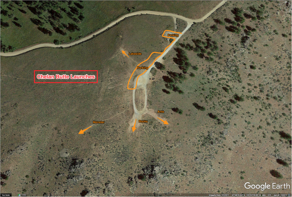
Set up areas on both sides are equipped with tie-downs. HG pilots MUST tie down to cables. Never leave equipment unattended. Strong dust devils often occur.
Use extreme caution when launching in thermic conditions. Severe turbulence can occur during or immediately after launch.
Ants
Glide to LZ: ~4.6:1 (to Chelan Falls Park).
Type: Grass, short shrubs, and bare dirt.
GPS Coordinates: 47.8041, -120.0383
Winds: 2-12 mph; ideal 5; gust factor 5 (PG). 5-12 mph; ideal 8; gust 8 (HG).
Notes: Use caution when wind is crossing from right.
Between the Rocks
Glide to LZ: ~4.6:1 (to Chelan Falls Park).
Type: Grass, short shrubs, and bare dirt.
Winds: 5-12 mph; ideal 8; gust factor 5 (PG). 5-18 mph; ideal 8; gust factor 5 (HG).
Notes: Shallow slope. Expect turbulence and wind shear during launch in thermic conditions. This tends to become more pronounced in lighter winds. HG pilots: Use aggressive flat-slope launch acceleration. Do not rely on headwind for airspeed.
Green Monster
Glide to LZ: ~4.6:1 (to Chelan Falls Park).
Type: Grass, short shrubs, and bare dirt.
Winds: 5-12 mph; ideal 8; gust factor 5 (PG). 5-18 mph; ideal 8; gust factor 10 (HG).
Notes: Becomes turbulent in stronger winds.
Lakeside
Type: Grass, short shrubs, and bare dirt.
GPS Coordinates: 47.8049, -120.0390
Winds: 0-15 mph; ideal 7; gust factor 10 (PG). 0-20 mph; ideal 10; gust factor 10 (HG).
Notes: Steeper slope, unobstructed launch. Best choice for light air and newer pilots.
Flying
Designated Landing Zones
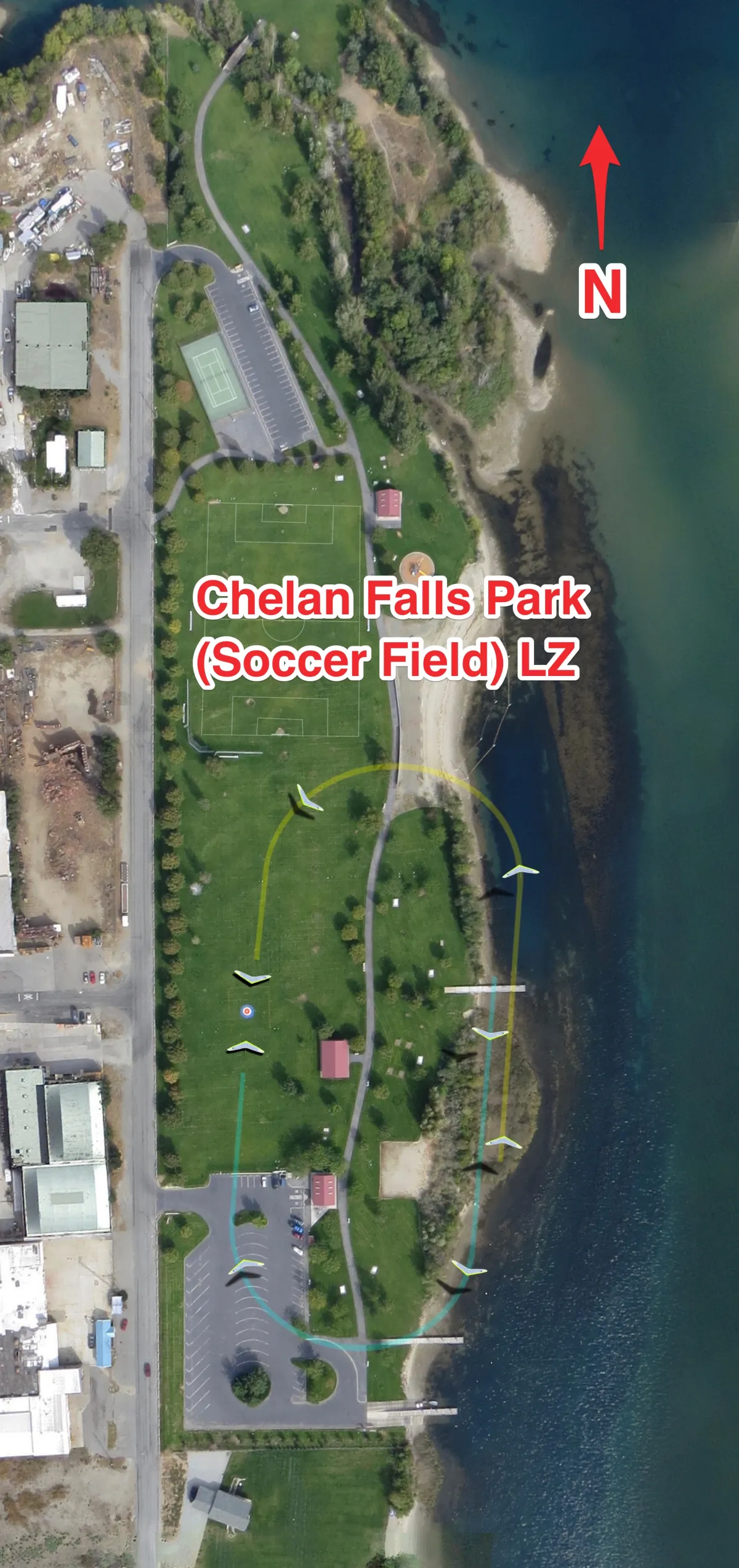
Chelan Falls Park (Soccer Field)
Elevation: ~700 ft MSL.
Type: Mowed and irrigated grass field.
Wind Sock: Flag and permanent wind sock at SE corner.
Obstructions: Narrow landing approach with water, trees, buildings. Large power lines to the north. Parking lot adjacent to south end of LZ.
Junkyard
Lone Pine (Closed)
The Lone Pine LZ next to Chelan Butte Road that appeared in previous site guides is currently closed. The landowner may start developing it without notice, so we can no longer recommend that pilots land there. Chelan Basin Conservancy has more information about this project.


